We are thrilled to announce new updates for DroneDB (v1.3.4) and Registry (v1.6.2)! These versions bring major enhancements, ensuring your aerial data management experience becomes smoother, faster, and even more productive.
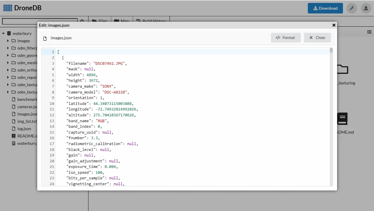
Built-in Text Editor with Syntax Highlighting
DroneDB Hub now includes a powerful text editor directly in your browser. View and edit text files without leaving the platform:
- Syntax highlighting for JSON, Markdown, XML, and more (powered by CodeMirror 6)
- Keyboard shortcuts: Ctrl+S to save, Escape to close
- “Open as Text” context menu option for any file type
- Maximum file size limit (5MB) with download fallback for larger files
- Autoformat JSON/XML files
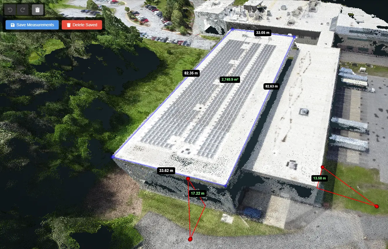
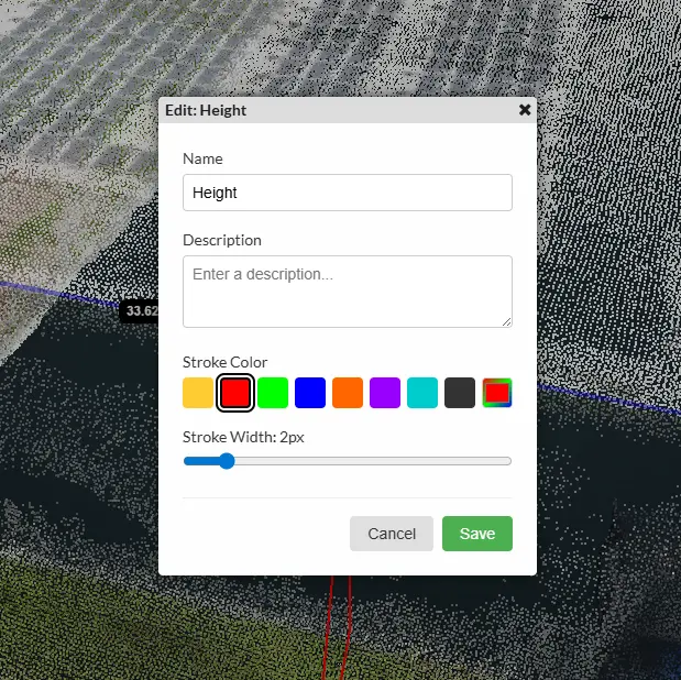
Advanced Measurement Tools
We’ve completely revamped the measurement experience in both 2D maps and 3D point clouds:
- Full undo/redo support (Ctrl+Z/Ctrl+Y) for all measurement operations
- Measurement edit mode: drag vertices to modify geometry, Shift+drag to move entire measurements
- Properties dialog: customize name, description, stroke/fill colors, width, and opacity
- Visual name labels that maintain constant screen size
- Annotation support in Potree: save and restore annotations alongside measurements
- GeoJSON persistence: measurements are now saved as standard GeoJSON files
- Tooltips showing measurement name and value on hover
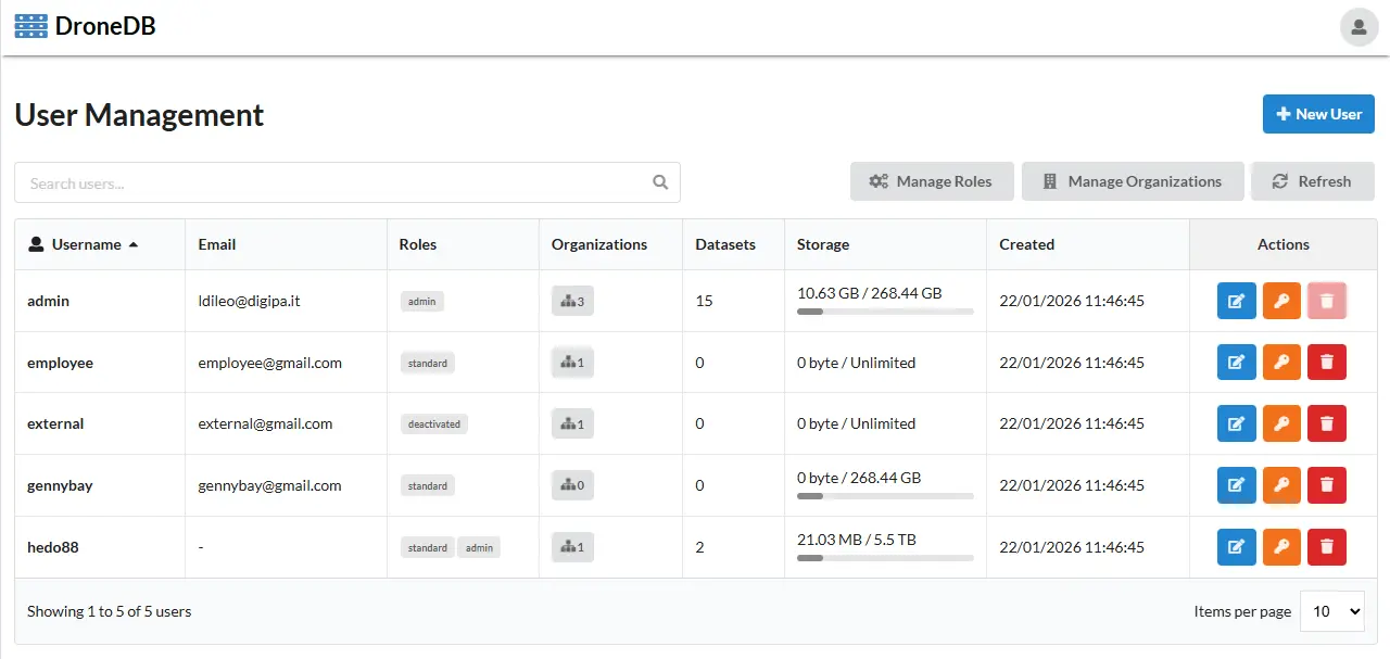
User Management Panel
A new admin panel makes user administration straightforward:
- Manage users, organizations, and roles from a dedicated interface
- Delete users with data transfer to a successor
- Configurable conflict resolution: Rename, Overwrite, or Halt
- Detailed deletion summary with transfer/deletion statistics
- Dataset permission enforcement in UI (read/write/delete)
Dataset Import, Merge & Rescan
New powerful utilities for managing your datasets:
- Import datasets and organizations from remote Registry instances
- Parallel import mode: downloads files individually with configurable workers
- Skip existing files with matching checksums for faster syncs
- Move datasets between organizations with conflict resolution
- Merge organizations: transfer all datasets and users to a destination
- Rescan dataset index to update metadata for existing files
Native glTF/GLB 3D Model Support
DroneDB now fully supports modern 3D model formats:
- Automatic conversion to OBJ/PLY for Nexus generation using Assimp
- Draco mesh compression support for optimized file sizes
- Smart format selection based on mesh properties (UV coordinates vs vertex colors)
- KTX2 to PNG texture conversion
- External resource dependency tracking
Improved Vector File Support
Vector file handling is now smarter and more reliable:
- Automatic reprojection to WGS84 (EPSG:4326) for proper web map display
- Spatial indexing for FlatGeobuf files enables efficient HTTP Range requests
- Smart CRS detection: skips reprojection for files without defined CRS
- Automatic PROMOTE_TO_MULTI fallback for mixed geometry types
- Optimized FlatGeobuf loading with proper bboxStrategy
Enhanced Point Cloud Processing
Point cloud handling has been improved across the board:
- ZSTD compression support via PDAL for better performance
- Improved reliability of point cloud thumbnails
- Fixed support for non-standard point cloud dimensions
- Fixed point cloud map projection coordinates
- Fixed EPT thumbnail generation
Performance & Reliability Improvements
Our development team has made significant efforts to optimize DroneDB:
- Extended HTTP download timeout to 24 hours for very large datasets (160GB+)
- Streaming file downloads to avoid memory issues
- Retry support with exponential backoff for file transfers
- Checksum-based change detection: builds only run when actual changes detected
- Dataset visibility caching with configurable expiration
- Fixed race conditions in concurrent database operations
- Optimized EF queries with improved indexing
Developer Experience
We’ve improved the developer experience with:
- Updated documentation with improved guides and API reference
- Modern Scalar API docs at
/scalar/v1(replaced Swagger UI) - Enhanced STAC support with title property for better display in STAC browsers
- Dataset Permissions API: endpoints return CanRead, CanWrite, CanDelete for current user
- SSL Certificate Verification Control: new
-k, --insecureflag - Comprehensive XML documentation on all API endpoints
Security & Privacy
- Fixed: Private datasets are no longer shown in public organizations
- New
/orgs/publicendpoint to list public organizations
Check the Updated Roadmap
We continually strive to improve and innovate DroneDB. Coming in 2026: multispectral imagery support, LDAP authentication, WMS/WFS OGC services, PDF viewer, file comparison tools, and AI-powered features.
Explore our updated roadmap to see what’s next and how we’re planning to further enhance your experience.
Your feedback is crucial! We thank you for your continued support and valuable suggestions. Stay tuned for more exciting updates and developments.
Happy flying!
The DroneDB Team